Satellite data has become an indispensable tool for understanding and addressing global development and environmental challenges. The integration of remote sensing technology into economic, social, and environmental research allows policymakers and scientists to monitor changes in land, water, and climate with unprecedented precision. Satellite observations provide large-scale, real-time, and historical information that supports evidence-based decision-making in areas such as agriculture, urban planning, disaster management, and climate adaptation. The growing accessibility of satellite imagery has transformed how researchers study environmental sustainability and economic development, especially in regions with limited ground-based data.
Table of Contents
Understanding Satellite Data and Its Relevance
Satellite data refers to information captured from Earth-observing satellites equipped with sensors measuring various physical and environmental parameters.
It includes imagery, radiometric data, and geophysical measurements of surface temperature, vegetation, water bodies, and pollution levels.
Governments, research institutions, and international organizations rely on satellite data for sustainable development planning.
The integration of satellite data with geographic information systems (GIS) and big data analytics enhances analytical accuracy and spatial visualization.
Types of Satellite Data Used in Development and Environmental Research
Type of Satellite Data
Description
Example of Application
Optical Imagery
Captures visible and infrared light for land cover analysis.
Tracking deforestation and crop health.
Radar (SAR) Data
Uses microwave signals to penetrate clouds and darkness.
Monitoring floods, soil moisture, and urban growth.
Thermal Data
Records surface temperature variations.
Studying heat islands and climate change effects.
Altimetry Data
Measures sea level, ice sheet height, and land elevation.
Observing glacial melting and coastal erosion.
Spectral Data
Detects chemical composition and vegetation indices.
Evaluating ecosystem productivity and pollution.
Role of Satellite Data in Development Research
Enables accurate mapping of infrastructure, population distribution, and land use.
Assists in monitoring agricultural productivity and supporting food security programs.
Provides timely disaster assessment for floods, droughts, and earthquakes.
Supports urban planning and transport modeling through spatial imagery.
Enhances health research by identifying correlations between the environment and disease patterns.
Environmental Applications of Satellite Data
Application Area
Use of Satellite Data
Key Outcome
Climate Monitoring
Tracking global temperature and greenhouse gas emissions.
Improved climate models and forecasting accuracy.
Forestry
Measuring forest cover, deforestation, and carbon sequestration.
Development of sustainable forest management strategies.
Water Resources
Mapping river basins, droughts, and groundwater depletion.
Efficient water allocation and conservation policies.
Biodiversity
Monitoring habitat loss and ecosystem fragmentation.
Support for wildlife conservation programs.
Air Quality
Measuring particulate matter and atmospheric gases.
Identification of pollution hotspots and health risks.
Benefits of Using Satellite Data in Research
Offers global coverage, enabling analysis across inaccessible or conflict-prone regions.
Provides consistent and repeatable measurements over long timeframes.
Reduces dependence on costly and time-consuming field surveys.
Enhances transparency and accountability in policy implementation.
Facilitates early warning systems for natural hazards and environmental risks.
Popular Satellite Programs and Their Contributions
Satellite Program
Agency
Primary Focus
Key Contributions
Landsat Series
NASA & USGS
Land use and environmental monitoring.
Provides long-term Earth observation data since 1972.
Sentinel Series
European Space Agency (ESA)
Climate, land, and ocean observation.
Supports global sustainability and agricultural programs.
MODIS
NASA
Atmospheric and surface monitoring.
Tracks vegetation, temperature, and carbon emissions.
Copernicus Programme
European Union
Environmental and security services.
Delivers free, open-access data for global research.
ISRO’s CartoSat and ResourceSat
India
Land resource management and urban development.
Supports planning in agriculture and disaster response.
Integration of Satellite Data with Other Datasets
Combining satellite data with census and survey data enhances the accuracy of poverty and inequality measurement.
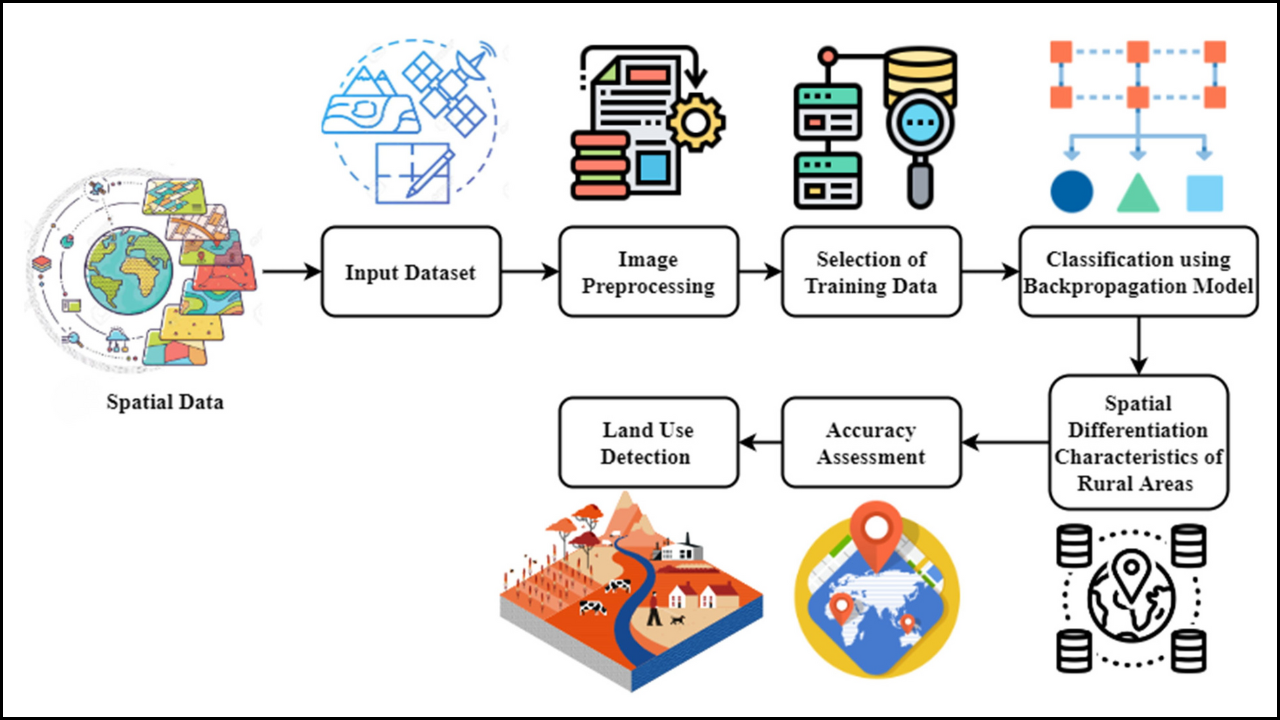
Machine learning and artificial intelligence are used to interpret satellite imagery for predictive analysis.
Big data frameworks allow researchers to handle terabytes of continuous Earth observation data efficiently.
Integration with climate models enables the simulation of future scenarios for agriculture, water, and health.
Challenges in Using Satellite Data
Challenge
Explanation
High Technical Complexity
Processing and interpreting satellite data require specialized expertise.
Data Storage and Access
Large datasets need robust computational infrastructure.
Cloud Cover Interference
Optical sensors cannot capture clear imagery under cloudy conditions.
Cost and Licensing Restrictions
Some commercial satellite data remain expensive or restricted.
Validation Requirements
Ground truth data are needed to ensure accuracy of interpretations.
Case Studies of Satellite Data in Development and Environmental Research
Deforestation Monitoring in the Amazon: Satellite imagery tracks illegal logging, leading to improved enforcement of forest protection laws.
Crop Yield Estimation in Sub-Saharan Africa: Satellite-based vegetation indices help governments estimate food production and plan imports.
Urban Expansion in Asia: High-resolution data reveal rapid urban growth, guiding sustainable infrastructure investment.
Flood Mapping in Bangladesh: Radar-based satellite data identify flood-prone regions, improving disaster preparedness.
Glacier Retreat Analysis in the Himalayas: Altimetry data measure the rate of ice loss, informing climate adaptation policies.
Technological Advancements Supporting Satellite Research
Technology
Function
Impact on Research
Cloud Computing
Processes large datasets remotely.
Enables real-time global monitoring.
AI and Deep Learning
Classifies land use and environmental patterns automatically.
Improves accuracy and scalability.
IoT Integration
Connects ground sensors with satellite feeds.
Provides multi-source data validation.
Open-Source Platforms
Provides free access to satellite tools and data.
Expands global participation in research.
Blockchain Technology
Ensures transparency in environmental data sharing.
Builds trust in sustainability reporting.
Policy Implications of Satellite Data Usage
Governments can design evidence-based development policies grounded in spatial data.
Satellite monitoring supports compliance with international environmental treaties.
Open-access satellite data fosters collaboration between research institutions and policymakers.
Real-time environmental monitoring allows for adaptive management and rapid response.
Accurate land-use data enables better resource allocation and urban regulation.
Future Directions in Satellite-Based Research
Expansion of nano-satellites and CubeSats will make Earth observation more cost-effective.
Integration with real-time climate sensors will enhance environmental forecasting.
The development of automated data analytics pipelines will reduce the time gap between data collection and application.
Use of high-resolution hyperspectral sensors will provide deeper insights into soil, water, and air quality.
Global cooperation on open satellite data sharing will democratize access for developing countries.
Emerging Research Fields Using Satellite Data
Research Area
Focus
Potential Contribution
Sustainable Agriculture
Monitoring crop health and irrigation efficiency.
Enhances food security and reduces waste.
Urban Planning
Mapping informal settlements and infrastructure needs.
Promotes inclusive urban growth.
Climate Adaptation
Tracking droughts, floods, and sea-level rise.
Strengthens resilience to climate shocks.
Public Health
Linking environmental pollution to disease spread.
Supports preventive healthcare policies.
Renewable Energy Planning
Identifying solar and wind potential zones.
Accelerates clean energy adoption.
The Way Forward
Satellite data has revolutionized development and environmental research by offering a comprehensive, real-time view of the planet’s changes. From tracking deforestation to guiding climate adaptation, satellite technology bridges the information gap between observation and policy. The growing integration of AI, big data, and open-access platforms ensures that satellite data becomes more accessible and impactful. As nations strive for sustainable growth, satellite-based insights will remain essential in designing data-driven policies that protect ecosystems, support development, and build climate resilience for future generations.
She is a creative and dedicated content writer who loves turning ideas into clear and engaging stories. She writes blog posts and articles that connect with readers. She ensures every piece of content is well-structured and easy to understand. Her writing helps our brand share useful information and build strong relationships with our audience.